
Almost 70% of areas in Wales are classified as coastal communities and there are many types of communities across these areas. Because of this, one homogenous policy approach across all areas is likely to be inappropriate. OCSI and Peter Brett Associates were commissioned by the Welsh Government to help consider how activities in the marine environment can support the socio-economic development of Welsh coastal communities.
The Welsh Government asked us to provide specific insights into the characteristics of the different coastal communities around Wales, based on a number of socio-economic factors so that marine planners and other users can understand which particular planning developments and policy initiatives may be appropriate in particular areas.
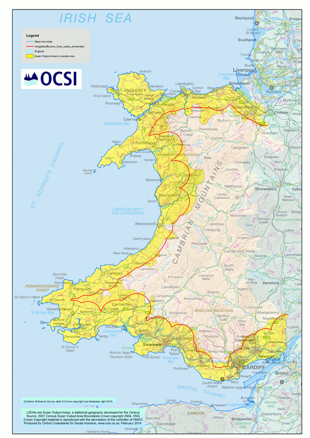
The extent of the “coastal” area defined for the purposes of the study. Red line shows the 10km coastal boundary from low water or defined estuary.
Yellow areas are those LSOAs with at least 15% of their geographical area lying within the 10km coastal boundary.
To gain a more detailed understanding of local coastal areas, we developed a typology of Welsh coastal communities, to differentiate between different types (or categories) of coastal area. The full report details our analysis of the typology, comparing between coastal areas and Wales as a whole, and also between the typology categories themselves.
We have defined ‘coastal’ (in accordance with the typology of English coastal communities) as
“extending 10km inland from the low water mark including around each defined estuary and river limit to include all transitional waters”
We used Lower Super Output Areas (LSOAs) as the base geographical unit for the definition of coastal in this study. There are 1,896 LSOAs in Wales, each with an average population of 1,500 people. Of these 1,896 LSOAs in Wales, just over 1300 are in coastal areas (69% of all Welsh areas).
The diagram below shows the nine coastal typology categories, grouped under four super-categories.

The nine coastal typology categories
There are further details on our methodology of developing the typology within the full report, as well as tables outlining each of the categories, summarising the main differences between each of the categories and the average position across coastal areas.
Take a look at the full report for an in-depth analysis of our findings of the differences between coastal and non-coastal areas in Wales. Some of the key headlines include:
Economy and labour market:
Vulnerable groups:
Areas changing over time:
The full report ‘Development of a Coastal Community Typology for Wales’ – OCSI and Peter Brett Associates – is now available online. If you would like any further information on this piece of research, please get in touch on info@ocsi.co.uk
For further reading take a look at our previous blog ‘Three suggestions for the coastal regeneration fund’ and our previous work with the English Marine Management Organisation ‘Coastal typologies: detailed methods and outputs’.
FInd out more about our research services.
Featured Image source: © https://www.walesonline.co.uk/news/wales-news/all-wales-coast-path-brought-millions-3184926

The English Community Needs Index (CNI) 2023 is now published as open…
More
Social housing providers have deep, experience-based knowledge of the communities they serve….
More
Many funding programmes use the Index of Multiple Deprivation (IMD) to identify…
More


